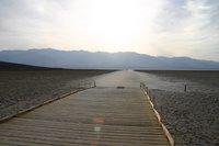
Wednesday 10th May- To Death Valley
The convoy parted ways at Kingman as we headed towards Death Valley and Joel and Stevie headed home to LA. Back across Hoover Dam, back past Vegas and past Area 51, finally driving though barren areas of land that Dick kept noting as being 'straight out of the X files'. It was difficult to see exactly where the valley began until we found our first information station. There we picked up a map and headed to Dante's View, where we first felt the heat of the area. The long twisty road up there was worth it for the views- miles and miles of barren nothingness. In the distance we could see both the highest point in California, Mount Whitney at over 14,000 ft above sea level, and the lowest point, Badwater, 262 ft below sea level. It was very dry and very hot.
We drove on to 'Zabriske's Point', where the rock formations look like huge claws of some unknown creature, and then to 'Badwater', the outside temperature continually rising. At 6 pm it was 105 degrees. Badwater is thought to be named after a traveller who wrote 'bad water' on his map after his donkey refused to drink it. No wonder, it is very salty!
 We walked on the salt crystals and gazed up at the mark on the hillside which showed where sea level is. The heat never leaves the valley as the surrounding mountains trap it in. We hit the perfect time for sunset again, this time over Artists Pallette, an area of naturally occuring strange coloured sand. We were definatley working up a thirst and a beer was foremost in Dick's mind. We were staying at Furnace Creek Ranch and we hit the bar!
Thursday 11th May- The longest day- Part 1
The longest day began with standing on sand dunes in the dessert- most peculiar and still no cooler first thing in the morning. A long barren drive north towards 'Scotty's Castle' where we bought a detailed map of California, and had our first incling that the day may turn out to be longer than we expected. We were heading towards Yosemite and happened to mention it to the ranger. She noted that the main route across the Sierra Nevada's was still closed due to heavy snowfall. Snow? In May? The map did say 'closed in winter'. Can't be that bad we thought. Want to bet??
Comments